 |
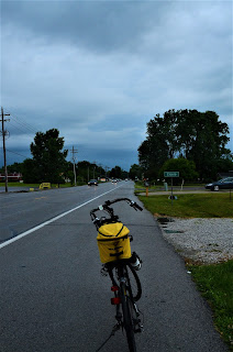
Heading to Cicero, Indiana.
7/8/2021 dwm photo |
On a recent visit to Indiana I brought my bike and managed to ride 73 miles over two days.
Rain was forecast the first time I could get out, but while it rained in buckets at times that day I only felt sprinkles while on the bike.
My goal as I rode away from the hotel was to find the White River Greenway path in Noblesville. I navigated the city streets to downtown where I crossed the river and found a familiar road I thought could take me someplace interesting.
Before I knew it, I was on state highway 19 heading to Cicero. Southbound traffic was heavy before 8 as commuters scrambled to get to work on time ahead of the rain. There was less traffic heading north, which was good because for long stretches (unlike the photo at left) where there was no pavement right of the white line.
I hoped to see a cool diner in Cicero. Instead I found rain which persuaded me to turn-around.
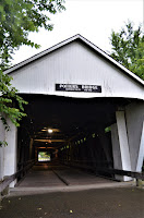 |
Potter Bridge.
7/8/21 (dwm) |
When I got back to Noblesville's Forest Park I asked about a bike path and the Potter Covered Bridge. I was less than two miles from the bridge and quickly found it just as I remembered.
When I took pictures of the bridge ten years ago (July 2011) I was shooting up river, heard a slight noise, turned and saw a doe and fawn stepping into the water. They didn't startle. After looking at me a few minutes they continued their walk. It was the first and only time I was that close to a deer.
I rode the length of the bridge across the river then down the White River Greenway path and city streets until reaching the hotel with time to clean-up before lunch.
The next day had better weather and a whole day to ride. When we lived in Indianapolis between 2005 and 2012, I rode the existing Monon Bike trail from its start downtown to the end of the trail just north of Carmel. It's expanded several miles north since.
While figuring out where to start Friday's ride, I noticed another bike path on the "things to do in Hamilton County" map. It's the Natalie Wheeler Trail.
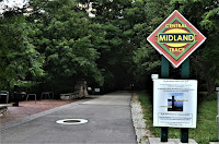 |
The Midland Trace trail in
Westfield. 7/9/21 (dwm) |
I parked in Cool Creek park, unloaded the bike and rode north on the path which was a over-sized sidewalk along South Union Street. The map showed the Wheeler path intersect with another, but I didn't have high hopes.
The Midland Trace trail surpassed all expectations! It stretched eight miles east along a former railroad line. The trees along the tracks now arched over the asphalt blocking wind and providing shade. It was perfect.
I rode as far as Hague Road where I crossed highway 32 and road another 2 miles before turning back. There were plenty of interesting things to see among the neighborhoods and subdivisions. Union Bible College's small campus in Westfield on Union Street made me stop and notice. It began in 1860 and established itself there in 1911.
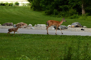 |
Mother and child out for a walk in Cool Creek
park. Westfield. 7/9/21 dwm photo |
The 16 mile trip concluded at the park where I took my camera for a short walk. As I approached Cool Creek I saw movement behind some trees and saw a doe and her fawn.
Moments later, mom walked out of the trees leading her child to the next patch of forest. They seemed at home, paying no attention to me or a mom and her two children who excitedly watched from a distance.
Just a day earlier I was in the same spot where ten years earlier I got my only picture of a doe and fawn. Less than 15 miles away, I re-lived the experience. It was special.
 |
Big bike art piece along the Monon trail in
Carmel. 7/9/21 dwm photo |
Several miles from Cool Creek, I parked at the Monon Community Center in Carmel aiming for the current end of the line in Sheridan.
While I had been on the Monon trail in Carmel before, the city has made considerable improvements since my last trip, adding art, stylized lanes and improved crossings of city streets.
I was moving along nicely when I noticed a spur trail to my right while I continued straight on what I thought was the Monon trail. Unknown to me at the time, I was again on the Midland Trace trail.
I followed it until it stopped in a city park, then followed a pair of cyclists who told me the trail ended up ahead. I thought I was in Sheridan, but didn't see anything to confirm it. A mile or two later, the asphalt ended abruptly six feet from a corn field.
 |
A bike and pedestrian bridge crosses
State Highway 32 in Westfield. 7/9/21 (dwm) |
After turning around, I asked a walker how I missed the big bridge that lifts the Monon Trail over highway 32. She told me to return to the intersection where I went straight and this time take the other route. A couple turns later, there was the bridge (photo right).
The bridge is fantastic with a gentle slope for the biggest hill on the Monon Trail. North of 32 the trail continues through Westfield past the Grand Park sports campus.
Grand Park is a huge center designed primarily for youth sports. There are 26 baseball and softball diamonds (all busy as I rode past); 31 multi-purpose fields for football, soccer, and lacrosse; an indoor facility which holds 3 full-size soccer fields; plus another facility used by the NBA's Indiana Pacers which hosts basketball and volleyball.
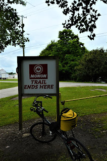 |
Monon's end of the trail.
7/9/2021 dwm photo |
The large maps posted along the trail ended at 203rd Street but the trail kept going. I asked a passing rider how far it was to Sheridan.
He said I couldn't miss the sign at the end of the trail (photo left). He was right.
Time for lunch. Other than a Dairy Queen and two convenience stores, I didn't see anything, so I asked an employee in one of the gas stations and he pointed the way to Ag's Café.
Inside were 10 tables with locals enjoying their lunch and robust conversation. I found a small table, ordered a burger and lemonade.
A short time later, my made-to-order burger and fries arrived to re-energize me for the return trip.
On the way back I took a detours on Greyhound Pass and the Hagan-Burke Trail to see where they led. The Pass became complete at Carmel High, home of the Greyhounds, and the Hagan-Burke was the link for two sections of Carmel to reach the Monon.
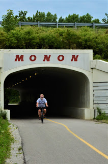 |
A rider exits the tunnel under
U.S. 31 in Carmel. 7/9/21
(dwm) |
On the sections of trail passing through neighborhoods there are as many or more walkers and runners than bikes. Some use the trail for exercise while others use it as a thoroughfare to reach stores, restaurants, or friends.
At 111th Street in Carmel stands the Monon Center and Waterpark at Central Park. It's a large area filled with wildflowers. There is splashpad and playground for young families. Closer to the Center is a large waterpark with places to play and swim. Inside the center are pools and courts for all ages.
There is talk of the Monon someday reaching another 38 miles north to the city of Kokomo.
The Monon was the name of the rail line that stretched from Louisville, Kentucky to Chicago, Illinois whose history dates back to the 19th century.
While the locomotives have long been silent, it's nice to see sections of track coming back to life at a slower pace.


Comments
Post a Comment